
The sections below that are underlined are each of a book or map (map set) they are in the order that they are shown on the slideshow. If you want to see a close up of either slideshow just click on the slideshow and it will take you to a larger view.
Don't forget to check out the cookies... my dd Rachel 22 designed and cut by hand the sugar cookies. Then she put the base icing on. Then she, my dd 19 Jessica, my ds Nathan 14 and my ds Christopher 11 decorated them. The first cookies without a person were done by Rachel and Jessica. Then there are three pictures of the boys and their cookies.
So here are the mini books and maps - in order of appearance in the slideshow at the top
Olympic Mascots through the years mini book
Here are some articles on the Olympic mascots through the years: http://www.boyslife.org/features/4560/olympic-mascots-through-the-years/
http://www.mapsofworld.com/olympic-trivia/olympic-mascot.html
http://inventorspot.com/articles/the_top_10_coolest_olympic_mascots_16307
http://www.hickoksports.com/history/olmascots.shtml
I used the sites above to compile information and get photos of the mascots. I printed out the pictures of the mascots and we pasted them in a mini booklet. I used ¼ size pages with lines to make it easier for the kids to write the descriptions about the mascots. I got the ¼ pages from my Dinah Zike Big book of projects. (The sample booklet is mine... so my writing not my kids... that is why it looks so neat and I used my calligraphy markers for part of it.)
Summer Olympics Logos
the websites I used:
http://www.mapsofworld.com/olympic-trivia/olympic-emblem.html
http://www.2008beijingolimpics.com/the-olympics/feature-all-the-olympics-logos-from-1896-to-2012/
I used the information from the top site and put it in a writing program then put it in two columns and then adjusted it so the pictures and text stayed together and were not split by the columns or the page changes then printed it. The kids then had a choice of how to display the information. I put mine in a timeline format – an accordion fold, one of the kids did a booklet.
Map of the Torch Run
sites:
http://torchrelay.beijing2008.cn/en/journey/map/
http://www.abcteach.com/free/m/map_china_wtaiwan.pdf
http://commons.wikimedia.org/wiki/Image:A_large_blank_world_map_with_oceans_marked_in_blue.PNG
Note...
for the first map... this is the one I printed for the kids to do their map from... you have to click play then click stop before it gets to the detailed map of China and then click print. If you miss it the first time or the second time... etc. just keep trying. Click stop when the last dot on the mainland by China turns blue and not orange. Then print. Then push play again and then stop it when the arrow gets to the last dot on the China map... Beijing. Press stop then print. This was the best representation of a map for the torch run that I found. If you have questions leave a comment and I will get back to you.
I also put the links for the outline maps I used. You can of course use others.
Map the Modern Olympics
http://www.teachinglearning.com/free-teaching-ideas-display.php?type=C
click on download next to the following page - Olympic Sites and Years Flag Match and Geography Mapping Activity (527)
I did not want to try to squeeze all the dots onto the Europe map... there are so many in that area it was impossible... so I printed a map of Europe from this site
http://www.yourchildlearns.com/megamaps/print-europe-maps.html
I printed the Europe map 1x1 1 page
on my world map I outlined the area in orange that I was going to cover on the Europe map and put “see larger map”
I did the Olympic sites in different colors:
one color (purple) for the summer Olympics before they had the winter Olympics (1896-1924) or you can do it the same color you do Summer Olympics since it is technically under that category, but I wanted it separated to show more pronounced when the winter Olympics started
one color for the summer Olympics
one color for the winter Olympics
one color for the future Olympics
Maps of the Countries Participating in the 2008 Beijing Olympics
list of the countries participating in the Beijing Olympics
cross out (not participating or covered under another name)
Bohemia, Czechoslovakia, East Germany, West Germany (keep just Germany they play together now), Soviet Union (now Russia), United Kingdom (Great Britain), Yugoslavia
add: Marshall Islands MHL, and Tuvalu
other great resource for the Participating Countries Map is:
Excellent resource – click the map and it will highlight the name or click the name and see the map
http://www.nbcolympics.com/countries/index.html
another list
http://www.mapsofworld.com/olympics/beijing-2008-olympics/participating-countries.html
we did these on a variety of maps.. it would work fine on the maps from Owl & Mouse Educational Software from this part of their site
http://www.yourchildlearns.com/megamaps.htm
Coloring one map for each of the following areas... leaving white the areas that are covered on another map.
Here is the list of maps we did:
Middle East (can be done as part of another map but I wanted it separate)
Asia
Africa
Europe
North and Central America
South America
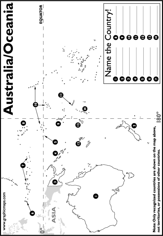
Australia/Oceania
The best map for Australia/Oceania I found at
http://www.worldatlas.com/webimage/testmaps/oceania.gif
we could just list the names according to the #'s and only colored Australia, New Zealand, and Papau New Guinea I had to add a couple #16 American Samoa, #16 Cook Islands, and #17 Guam ( the islands are on the map but not numbered)
Oh I should put a solution for that map on here ... ok... this is how I labeled our islands... If you think I am wrong... don't tell me... LOL. OK tell me but it is to late to change it.. we are all done this map.
- Australia
New Zealand
Papua New Guinea
Solomon Islands
Nauru
Palau
Micronesia
Marshall Islands
Tuvalu
Kiribati
Samoa
Vanuatu
Fiji
Tonga
add 15-17 see above
new website addition – coloring pages for the FUWA
http://www.activityvillage.co.uk/olympics_coloring_pages.htm
leave a comment or question
 Debbie
3 comments:
Hi, Debbie! I "discovered" you by participating in Cindy's "Let's Get Organized" seminar and am now a member of the Let's Get Real Yahoo group. I love your new name of "Debbie most helpful" - LOL! I don't have much time to look around your blog at the moment, but I do appreciate all those links on the side; I love links! Thank you! Blessings, Danielle
Hey Debbie-that is a wonderful project you all did. I especially like the cookies-do you have a mail order for em? Mmmmmm.
Have enjoyed chatting with you on the CR Talk-A-Latte as well. Keep up the good work!
Debbie,
The cookies looked fantastic! Maybe you can teach the boys and I how to make pretty cookies sometime. I stick to the bar or drop ones for the most part.
With no TV during most of the Olympics, I have to confess we skipped that learning opportunity altogether. Thanks for sharing all the great resources you found and what the kids did for the unit.
School's just starting back up next week in our house. Unpacking from the move is slow going, but I can't stand to wait any longer.
Post a Comment